Envis Centre, Ministry of Environment & Forest, Govt. of India
Printed Date: Tuesday, December 16, 2025
Types of Clouds
Clouds are given different names based on their shape and their height in the sky. Some clouds are near the ground. Others are almost as high as jet planes fly. Some are puffy like cotton. Others are grey and uniform.
The name of a cloud may describe its appearance. Cloud classifications were devised in the early 19th century by an Englishman named Luke Howard who classified clouds using Latin words. Clouds form in three basic patterns:
►Cirrus, from cirro, meaning curly or fibrous
► Stratus, from strato, suggesting sheets or layers
►Cumulus, from cumulo, indicating heaped or piled
By combining other terms, a number of different cloud combinations can be described. The different types of clouds are described here.
High Clouds, which located at altitudes above 20,000 feet
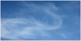 (a) Cirrus (Ci): Detached clouds in the form of white, delicate filaments, mostly white patches or narrow bands. They may have a fibrous (hair-like) and/or silky sheen appearance. Cirrus clouds are always composed of ice crystals, and their transparent character depends upon the degree of separation of the crystals. As a rule when these clouds cross the sun's disk they hardly diminish its brightness. Before sunrise and after sunset, cirrus is often colored bright yellow or red. These clouds are lit up long before other clouds and fade out much later.
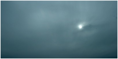
 (b) Cirrostratus (Cs): Transparent, whitish veil clouds with a fibrous (hair-like) or smooth appearance. A sheet of cirrostratus which is very extensive, nearly always ends by covering the whole sky. A milky veil of fog (or thin Stratus) is distinguished from a veil of Cirrostratus of a similar appearance by the halo phenomena which the sun or the moon nearly always produces in a layer of cirrostratus.
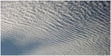
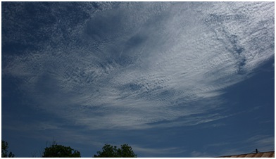 (c) Cirrocumulus (Cc): Thin, white patch, sheet, or layered of clouds without shading. They are composed of very small elements in the form of more or less regularly arranged grains or ripples. In general Cirrocumulus represents a degraded state of cirrus and cirrostratus both of which may change into it and is an uncommon cloud. There will be a connection with cirrus or cirrostratus and will show some characteristics of ice crystal clouds.
Mid Clouds: These are found between 6,000 and 20,000 feet above the ground.
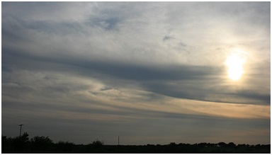
 (d) Altostratus (As): Grey or bluish cloud sheets or layers of striated or fibrous clouds that totally or partially covers the sky. They are thin enough to regularly reveal the sun as if seen through ground glass. Altostratus clouds do not produce a halo phenomenon nor are the shadows of objects on the ground visible. Sometime virga is seen hanging from Altostratus, and at times may even reach the ground causing very light precipitation.
 (e) Altocumulus (Ac): White and/or grey patch, sheet or layered clouds, generally composed of laminae (plates), rounded masses or rolls. They may be partly fibrous or diffuse. When the edge or a thin semitransparent patch of altocumulus passes in front of the sun or moon a corona appears. This colored ring has red on the outside and blue inside and occurs within a few degrees of the sun or moon. The most common mid cloud, more than one layer of Altocumulus often appears at different levels at the same time. Many times Altocumulus will appear with other cloud types.
 (f) Nimbostratus: The continuous rain cloud. Resulting from thickening Altostratus, This is a dark gray cloud layer diffused by falling rain or snow. It is thick enough throughout to blot out the sun. The cloud base lowers into the low level of clouds as precipitation continues. Also, low, ragged clouds frequently occur beneath this cloud which sometimes merges with its base.
Low Clouds: These are found 6,000 feet or lower
 (g) Cumulus: Detached, generally dense clouds and with sharp outlines that develop vertically in the form of rising mounds, domes or towers with bulging upper parts often resembling a cauliflower. The sunlit parts of these clouds are mostly brilliant white while their bases are relatively dark and horizontal.Over land cumulus develops on days of clear skies, and is due diurnal convection; it appears in the morning, grows, and then more or less dissolves again toward evening.
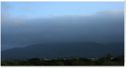 (h) Stratus: A generally gray cloud layer with a uniform base which may, if thick enough, produce drizzle, ice prisms, or snow grains. When the sun is visible through this cloud, its outline is clearly discernible. Often when a layer of Stratus breaks up and dissipates blue sky is seen.
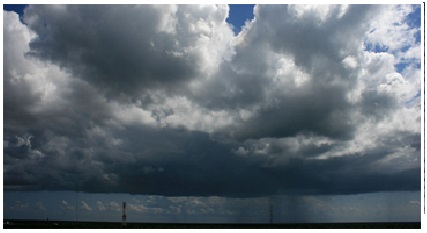
(i) Cumulonimbus: The thunderstorm cloud, this is a heavy and dense cloud in the form of a mountain 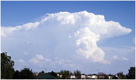 or huge tower. The upper portion is usually smoothed, fibrous or striated and nearly always flattened intheshape of an anvil or vast plume. Under the base of this cloud which is often very dark, there are often low ragged clouds that may or may not merge with the base. They produce precipitation, which sometimes is in the form of virga. Cumulonimbus clouds also produce hail and tornadoes.
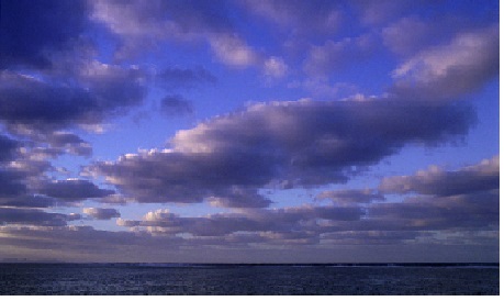 (j) Stratocumulus: Gray or whitish patch, sheet, or layered clouds which almost always have dark tessellations (honeycomb appearance), rounded masses or rolls. Except for virga they are non-fibrous and may or may not be merged. They also have regularly arranged small elements with an apparent width of more than five degrees (three fingers - at arm's length).
Sources:
National Weather Service-National Ocean and Atmospheric Administration