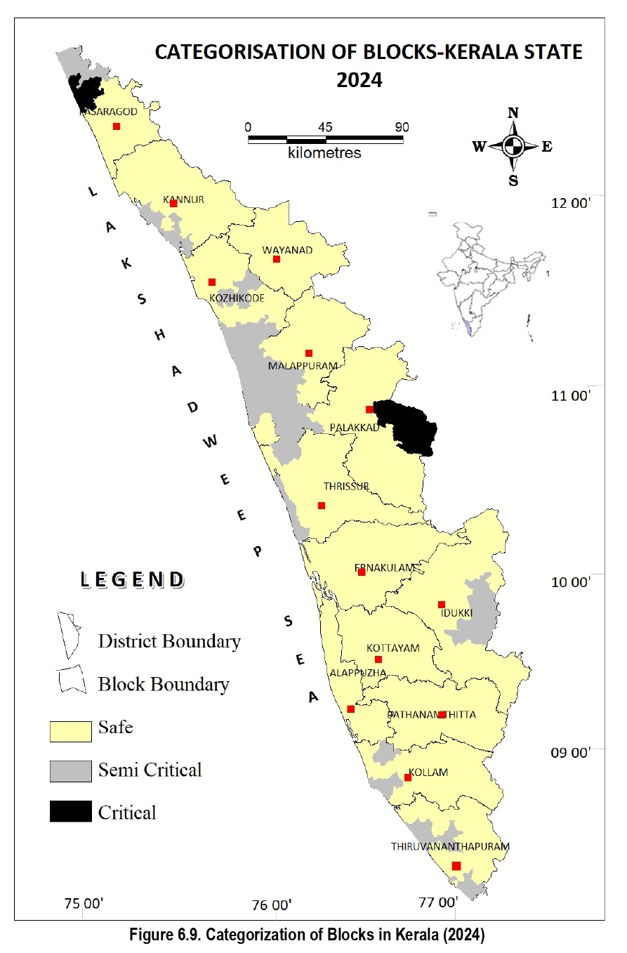
The Assessment units have been categorized as “Over-exploited”, “Critical”, “Semi-critical” and “Safe” based on Stage of Ground Water Extraction and the long-term decline of average ground water levels in the observation wells in the assessment unit. Out of 152 assessed units in the State, 3 blocks (Chittur & Malampuzha blocks of Palakkad district and Kasaragodblock of Kasaragod district) have been categorized as “Critical”; 29 blocks are “Semi-critical” and 120 blocks arein “Safe” category. The Stage of Ground Water Extraction and the block-wise long-term (2014-2023) water leveltrends of the observation wells being monitored by Central Ground Water Board and the State Ground Water Department for pre and post-monsoon were considered for categorization of the blocks. The spatial distributionof different categories of assessment units is given below:
(Source: Ground Water Resources of Kerala 2024)
The district- wise and block-wise numbers of assessment units under different categories are given here. Categorization of Critical and Semi critical blocks as in 2024 is given here.
District-wise Ground Water Resource Scenario
1. Alappuzha: The Annual Extractable Ground Water Recharge of the district is 360.44 MCM and existing Gross Ground Water Extraction is of the order of 141.77 MCM. The Stage of Ground Water Extraction is 39.33 %. All the blocks in the district are Safe from the point of view of ground water extraction.
2. Ernakulam: The Annual Extractable Ground Water Recharge of the district is 462.48 MCM and existing Gross Ground Water Extraction is of the order of 229.51 MCM. The Stage of Ground Water Extraction is 49.63%. All the blocks in the district are Safe from the point of view of ground water extraction.
3. Idukki: The Annual Extractable Ground Water Recharge of the district is 188.57 MCM and existing Gross Ground Water Extraction is of the order of 102.21 MCM. The Stage of Ground Water Extraction is 54.21%. Out of 8 blocks in the district, 2 have been categorized as ‘Semi-critical’ (Kattappana and Nedumkandam) and 6 blocks as ‘Safe’.
4. Kannur: The Annual Extractable Ground Water Recharge of the district is 398.53 MCM and existing Gross Ground Water Extraction is of the order of 198.25 MCM. The Stage of Ground Water Extraction is 49.75 %. Out of 11 blocks in the district, 3 have been categorized as ‘Semi-critical’ viz; Kannur, Thalassery and Panur and 8 blocks as ‘Safe’.
5. Kasaragod: The Annual Extractable Ground Water Recharge of the district is 314.18 MCM and existing Gross Ground Water Extraction is of the order of 228.57 MCM. The Stage of Ground Water Extraction is 72.75%. Out of 6 blocks in the district, 1 has been categorized as ‘Critical’ viz. Kasaragod; 1 as ‘Semi-critical’ viz. Manjeshwar block and 4 blocks as ‘Safe’.
6. Kollam: The Annual Extractable Ground Water Recharge of the district is 323.35 MCM and existing Gross Ground Water Extraction is of the order of 167.93 MCM. The Stage of Ground Water Extraction is 51.93%. Out of 11 blocks in the district, 2 blocks (Mukhathala and Sasthamkotta) is ‘Semicritical’ and 9 blocks are ‘Safe’.
7. Kottayam: The Annual Extractable Ground Water Recharge of the district is 370.31 MCM and existing Gross Ground Water Extraction is of the order of 137.44 MCM. The Stage of Ground Water Extraction is 37.11%. All the blocks in the district are in ‘Safe’ category.
8. Kozhikode: The Annual Extractable Ground Water Recharge of the district is 306.28 MCM and existing Gross Ground Water Extraction is of the order of 188.98 MCM. The Stage of Ground Water Extraction is 61.70%. Out of 12 blocks in the district, 3 are ‘Semi-critical’ (Balussery, Kozhikode and Kunnamangalam) and others are ‘Safe’.
9. Malappuram: The Annual Extractable Ground Water Recharge of the district is 484.34 MCM and existing Gross Ground Water Extraction is of the order of 346.53 MCM. The Stage of Ground Water Extraction is 71.55 %. Out of 15 blocks in the district, 8 are ‘Semi-critical’ (Kondotty, Kuttipuram, Malappuram, Mankada, Thanur, Thirurangadi, Tirur & Vengara) and remaining blocks are ‘Safe’.
10. Palakkad: The Annual Extractable Ground Water Recharge of the district is 567.68 MCM and existing Gross Ground Water Extraction is of the order of 339.21 MCM. The Stage of Ground Water Extraction is 59.75%. Out of 13 blocks in the district, 2 are ‘Critical’ (Chittur & Malampuzha), 2 blocks are ‘Semicritical’(Pattambi and Thrithala) and 9 blocks are ‘Safe’.
11. Pathanamthitta: The Annual Extractable Ground Water Recharge of the district is 208.70 MCM and existing Gross Ground Water Extraction is of the order of 78.53 MCM. The Stage of Ground Water Extraction is 37.63%. All the 8 blocks of the district have been categorized as ‘Safe’.
12. Thiruvananthapuram: The Annual Extractable Ground Water Recharge of the district is 257.82 MCM and existing Gross Ground Water Extraction is of the order of 174.62 MCM. The Stage of Ground Water Extraction is 67.73 %. Out of 11 blocks, 6 are ‘Semi critical’ (Athiyannur, Chirayinkil, Nedumangad, Parassala, Pothencode and Varkala) and 5 are ‘Safe’.
13. Thrissur: The Annual Extractable Ground Water Recharge of the district is 558.81 MCM and existing Gross Ground Water Extraction is of the order of 340.55 MCM. The Stage of Ground Water Extraction is 60.94%. Out of 16 blocks in the district, 3 are ‘Semi-critical’ (Chowannur, Mathilakam and Thalikulam). All the other blocks are safe.
14. Wayanad: The Annual Extractable Ground Water Recharge of the district is 203.78 MCM and existing Gross Ground Water Extraction is of the order of 56.48 MCM. The Stage of Ground Water Extraction is 27.67 %. All four blocks in the district are ‘Safe’.
Groundwater Management
The State Ground Water Department is thenodal agency for groundwater development and management in the State and it extends demand-based services to private individuals and Government agencies. Groundwater conservation and recharge is a major activity being implemented by the Department to sustain groundwater availability. For ensuring the quality of Groundwater, the Department has initiated measures to formulatea State-wide groundwater quality plan. From each District, one block severely affected by water quality issues will be selected for collection of water samples from observation wells. The samples will be quality tested in the respective regional labs of the department. A total of 860 samples were collected and analysed from Idukki, Thiruvananthapuram, Kollam, Pathanamthitta, Alappuzha, Ernakulam and Kottayam Districts.The data thus obtained will help in addressing the issues by suggesting suitable remedial measures and also by making the public aware of the situation. Also, during the period, the Department has initiated the conduct of well census for the collection of ground water abstraction data. Through Kudumbasree Mission, data collection was carried out partially in 39 blocks using mobile app ‘Neerarivu’, there by completing 45 per cent of data collection. The validated data will be usedfor accurate budgeting of water resources of the particular block.
Other Resources:
Apart from rivers and wells sources like tanks, ponds, springs and surangams are also use in Kerala for providing water for drinking as well as irrigation. It is estimated that Kerala has approximately 995tanks and ponds having more than 15000 Mm³ summer storage. Natural springs occurring in the highland regions of Kerala state have the potential to be developed as good sources for drinking water supply and also for limited small scale irrigation, especially in remote and under developed areas. A total of 236 springs have been identified in the state. Kasaragode district in Northern Kerala has 510 special kind of water harvesting structure called Surangams which have >111pm discharge.
Hydrology Information Systems:
The State has 41 west-flowing and three east-flowing rivers, and has an average annual rainfall of about 3,000mm. However, the extent to which it can retain, store, and use these for agricultural purposes is still inadequate. In order to have a realistic assessment of water resources in the State, the Investigation Design and Research Board of Irrigation department is in the process of modernising the existing hydrology information system with a Real-Time Data Acquisition System. The core activity of the hydrology wing of the Irrigation department is the collection, validation, and collation of hydro-meteorological data from various gauging stations, established across Kerala river basins. The National Hydrology Project, funded by World Bank, also aims at improving the quality and accessibility of water resources information and to strengthen the capacity of water resources management institutions in the State. The objective is to establish an effective hydrologic database and hydrological information system for effective water resources planning and management.
The consecutive floods of 2018 and 2019 necessitated an early flood warning system for the State. Flood Forecasting and Early Warning System (FFEWS) integrated with reservoir operations for Periyar and Chalakudy basins were initiated during the 13th Five-Year Plan period under the National Hydrology Project. FFEWS acts as an end-to-end system for issuing timely warning against disaster. The accuracy of the forecast depends on the real time hydro-met data received, and the quality of topographical features.
Irrigation Status:
As per the assessment of the Directorate of Economics and Statistics, the extent of irrigation in the State in 2022-23 had slightly varied when compared to the previous year. As reported, the net area irrigated in the State in 2023-24 increased to 4.19 lakh ha as compared to the 2022-23 figure of 4.18 lakh ha, showing a marginal increase of 0.23 per cent. The percentage of net area irrigated to net area sown had risen from 19.9 (2021-22) to 21.3 (2023-24). However, a decline is reflected in the Gross Irrigated area with a fall in the area from 5.61 lakh ha (2021-22) to 5.31 lakh ha (2023-24). This decline is also reflected in the percentage of gross irrigated area to gross cropped area which fell from 22.3 per cent (2021-22) to 21 per cent in (2023-24).
Among the various sources of irrigation, the net area irrigated through wells (including bore wells) leads with 1.83 lakh ha during the review period, whereas the benefitted area was 1.77 lakh ha in 2022-23. The extent of net area irrigated through Government canals also showed a decrease from 0.81 lakh ha (2022-23) to 0.77 lakh ha (2023-24). Details on the net area irrigated (source-wise and District-wise) are given are given below:
|
Net Area Irrigated (Source wise) (in Ha.)
|
|
Source
|
2021-22
|
2022-23
|
2023-24
|
|
Government Canal
|
72491.00
|
81985.68
|
77638.28
|
|
Private canals
|
257.00
|
292.63
|
173.86
|
|
Tanks
|
47588.00
|
45806.27
|
47906.96
|
|
Wells
|
121764.00
|
121169.76
|
129096.09
|
|
Other sources
|
161135.00
|
169333.58
|
165075.64
|
|
Total
|
403235.00
|
418587.92
|
419890.83
|
|
Gross irrigated area
|
561314.02
|
514497.97
|
531870.53
|
|
Net area irrigated to net area sown (%)
|
19.87
|
21.02
|
21.28
|
|
Gross irrigated area to gross cropped area (%)
|
22.25
|
20.45
|
20.97
|
|
Irrigated area under paddy to total irrigated area (%)
|
27.44
|
29.89
|
30.12
|
|
Source: Directorate of Economics and Statistics
|
Net Area Irrigated (District Wise) 2023 - 24 are given here.
Crop-wise, paddy and coconut were the crops most benefitted through irrigation. The gross area irrigated under paddy had slightly increased to 1.60 lakh ha (2023-24) from 1.53 lakh ha (2022-23). But the area irrigated under coconut shows a significant increase to 1.63 lakh ha (2023-24) from 1.56 lakh ha (2022-23). Compared to the previous year, the vegetables irrigated area had remained the same 0.29 lakh ha (2023-24). But banana had benefitted through irrigation reaching 0.42 lakh ha (2023- 24) from 0.40 lakh ha (2022-23). Details on gross area irrigated and crops benefitted are given here.
Status of Major and Medium Irrigation Projects
Agriculture and irrigation are intricately linked, as irrigation plays a crucial role in enhancing crop Major and Minor irrigations are vital for optimizing agricultural output, particularly, in regions prone to drought or irregular rainfall, thereby sustaining livelihood and promoting economic growth. The implementation progress of Idamalayar, Karapuzha and Banasurasagar irrigation projects are described below:
The main canal of the Idamalayar Irrigation Project, having a length of 32.278 km as completed for irrigating an ayacut of 999 ha. The construction of railway crossing portion of Low-Level Canal (LLC) at ch.13,818.5m in Angamaly Municipality and the construction of tail end discharge at ch.14,623m in Nedumbassery Panchayat has been completed. The construction of flush escape (ch. 14,623) has been started and the portion of Bhoothamkutty branch canal (ch. 3,550m) and its off take point (ch. 909 km) has to be modified as link canal. Out of the total length of 7.500 km, 2.035 km of the link canal was completed. Steps for augmenting the benefit of field channels and natural thodu have been completed and additional 85 Ha ayacut was achieved. For stabilising the existing ayacuts, maintenance of damaged portions of canals were carried out. In 2023-24, 4,270 ha ayacut has been achieved.
The Karapuzha project, originally envisaged as an irrigation project has now transformed into a multi-purpose project with drinking water supply, tourism, power generation and fisheries projects. In the Karapuzha Irrigation project, the entire Left Bank Main Canal (LBMC) up to the tail end (ch. 16,740 m) is now made functional for irrigating an ayacut of 245 ha. Water distribution up to the tail end of LBMC was done on March 15, 2023 on a trial basis. Having completed the rectification works of the breach in the Right Bank Main Canal (RBMC) between ch.7,673m and 7,888m, water distribution up to the tail end (ch.8,805m) is being done in 2023, thereby irrigating 331 ha. Thus, the water distribution through main canals and Arimunda distributary (60.31 ha) helped in achieving a total ayacut of 636.5 ha. Moreover, water distribution through Kolliyil Branch Canal (up to ch. 1,540 m) was also done on a trial basis on March 8, 2023. Thus in 2022-23, both the main canals (25.5 km) and the Kollayil Branch Canal (1.5 km) of the Karapuzha project were made functional for the first time. Water distribution through both the main Canals, Left Bank Main Canal of 16.7 km length serving an ayacut of 245.2 ha (ch. 0-16,740) and Right Bank Main Canal of 8805 m length serving an ayacut of 330 ha (ch.0- 8,805) up to tail end has become possible as rectification works of canal breach at ch.4,800m of Left Bank Main Canal (LBMC) had been completed in 2023-24. The completion of major works at ch.1,800m and the ongoing rectification works of the Padinjareveedu Branch Canal has enabled water availability for 358 hectares of agricultural land. The full commissioning of the Karapuzha irrigation project will benefit the local farmers, particularly, the most populated Tribal/Adivasi people of Wayanad District.
A major constraint of the Banasurasagar Irrigation Project was the bottleneck from ch.1,130m to 1,500m in the Main Canal. The Department has succeeded in overcoming this constraint and 39 per cent works have been completed. Additional 0.56 ha of land is required for the completion of Kappumkunnu distributary. As an initial procedure of land acquisition, peg marking of 0.1 ha of land has been done in Kappumkunnu distributary. In 2023-24, water test was conducted in the aqueduct portion of the Main Canal from ch. 0m to ch. 150m. Completion of 1101m of Kappumkunnu distributary, 585 m of Pearl distributary and 1,190 m of Venniyode branch canal, land acquisition and peg marking of 0.4 ha of land in Kuppadithara distributary and completion of soil investigation for the aqueduct portion of various distributaries are few other project related activities carried out during the period.
Minor Irrigation:
Minor irrigation (MI) schemes have contributed substantially to augment the irrigation potential in the State. Minor Irrigation has its own importance due to low gestation, less investment and quick benefit. Kerala’s undulating terrain makes major irrigation projects expensive, giving minor irrigation schemes a definite advantage over the Major Irrigation Schemes. The importance given to Minor Irrigation during the 13th Five Year Plan period is being continued during the 14th Plan period.
Surface Water
During the 13th Five Year Plan period, through various surface water MI schemes, 23,601 ha of ayacut was achieved. The net area benefitted through MI schemes (surface water) in 2023- 24 was 4179 ha. Details of physical achievement of MI schemes (surface water) during 2022-23 to 2023-24 are given below. NABARD has sanctioned 1,631 schemes under various tranches including RIDF XXIX. Of these, 1,364 schemes are completed and 17 are in progress. Remaining schemes are dropped due to non-feasibility reasons.
|
Physical Achievement of Minor Irrigation (Surface Water) (Net area in ha.
|
|
Name of Schemes
|
2022-23
|
2023-24
|
2024-25 upto August 31, 2024
|
|
MI Class I
|
1177.88
|
1138.80
|
334.32
|
|
MI Class II
|
1505.04
|
1039.69
|
446.13
|
|
Lift Irrigation works
|
883.90
|
530.51
|
174.24
|
|
Repairs to MI structure
|
1101.47
|
902.81
|
341.9
|
|
MI Class I – NABARD
|
407.80
|
567.02
|
1625.83
|
|
Total
|
5076.09
|
4178.83
|
2922.42
|
|
Source: Irrigation Department (I&A), GoK
|
Flood Management:
The Department recognises the increasing risk of flooding in Urban areas due to rapid urbanisation and climate change. As part of flood mitigation works, construction of flood bunds, enhancement of drainage systems, and development of small-scale reservoirs to manage excess rainwater are undertaken. In urban areas like Thiruvananthapuram and Kochi, specific strategies to create a resilient urban environment capable of withstanding severe weather events while minimising disruption to daily life will be implemented.